Tuesday, November 8, 2016

Fall, 2016...Wisconsin -Two Guns - Rt 66 - Prescott 

Since I haven't been keeping up on our blog, I'll be doing some catch up.

We had a wonderful time in WI visiting family and friends. 
Beaver Dam Lake in Cumberland is one of our all time favorite spots, it's peaceful, beautiful and the water crystal clear. Nice sunsets too! 

Lambeau Field... a very special place for us Cheeseheads. 
WI Badgers - LSU game (WI wins!)

Iowa, Pikes Peak State Park - Our first night's stop after leaving northern WI.
Bluff overlooking the Wisconsin and Mississippi Rivers where they join together.
There's a very nice campground here.

While staying at Meteor Crater RV park near Winslow, we often walked old Rt 66, now abandoned and part of a ranch. Rt 66, (a.k.a The Mother Road), made it’s way from the midwest, thru Arizona, to the CA coast. 
The owner of the ranch allows people from the park to walk here. We found an old rusted headlight, the type that would be mounted on top a big fender. I was envisioning people traveling this rutted dusty road back in the 1930’s. It was a major pathway for those migrating westward especially during the dust bowl, later years more vacation travel. 

Ruins from Two Guns on old Rt 66
Businesses sprang up along the way, gas stations, diners and tourist attractions. About 5 miles from our campground on old Rt 66 is the ghost town of Two Guns situated on the edge Canyon Diablo. We rode our bikes to Two Guns, explored and again imagined what it must have been like back in the day. There’s a great deal of history here, some not so good. Dating back to 1878, the Apaches and Navajos had a very deadly confrontation here. Later years a trading post was built, then a lodge overlooking the canyon. With travel becoming popular, a make shift zoo was added to attract more tourists. Crumbling adobe buildings, busted wire cages, a faded Mountain Lion sign all remain. A gas station and campground were later additions, also in a crumbling state. When I-40 bypassed Two Guns (I think in the 60’s) and other small towns along Rt 66, these tourist towns dried up. Over the years, Two Guns had several people attempt to open new ventures, fires and other mis-adventures all led to failures, according to Indian lore it’s a haunted and cursed ground. There are entire books written about Two Guns and it’s history. We love this kind of exploring and learning about past history of these unique locations. What’s really cool about Two Guns is it’s a ghost town not a tourist trap, there are no signs, no paved sidewalks or souvenir shops.

As we're riding back from Two Guns, cattle cross old Rt 66.  One rule for using this road is if a gate is closed be sure to close it behind you. The trees on the far horizon is our RV park. 

While staying in Prescott, we found a great bike trail along Watson Lake, the Peavine Trail.  Beautiful scenery! I had to slam on my brakes when we came upon a large snake sunning itself on the trail. It wasn't a rattler, but the size freaked me out, especially since I didn't see it until my better half (riding behind me) yelled "SNAKE!" that's when I hit the brakes and stopped just a few feet short of it.  (Our son and wife might remember hiking here in the boulders a few years back when they visited us.)
We really like Prescott. It’s an old cowboy town that has maintained it’s feel of days gone by. Lovely quaint downtown with a courthouse square, huge white courthouse in the middle, very enjoyable place to walk. One side of the square is named Whiskey Row as it was back in the late 1800’s, it’s now listed as a Historic District. The street was lined with saloons. One in particular was quite famous, The Palace. In 1900 a massive fire burned the entire block of whiskey row, the wooden buildings had little chance of surviving. The locals knew there was no hope in putting out the fire so they carried the beautiful wooden bar and a large wooden ice chest out of the Palace across the street to where the courthouse sits today. Rebuilding started soon after the fire, this time using brick as building material. The original bar was put back into the newly constructed Palace which was completed in 1901. The Palace remains in operation today and looks very much like it did 100 years ago. Entering through the wooden swinging bar doors reminded me of the Gunsmoke shows we watched. On weekends there are people that (volunteer) dress in attire of that period. Civil war soldiers, lawmen etc. These guys greet patrons and talk history, they’re very knowledgeable historians and so interesting. We talked to an older “lawman” for quite some time, come to find out, he really was a lawman, retired police officer from Massachusetts. We learned Virgil Earp lived in Prescott. His brother Wyatt and Doc Holiday spent a lot of time in Prescott with Virgil, this was before they headed to Tombstone where the famous Shoot out at the OK Corral took place. The lawman/historian told us as we sat at the bar (eating our cheese curds), that Wyatt Earp, Virgil and Doc Holiday had all leaned on the very same bar. I just thought that was so cool as my mind wandered back 100 years. He also said they wouldn’t have been sitting on bar stools as we were, the patrons back then all stood at the bar. (I do remember watching the old westerns, most the cowboys did stand.) 


At White Spar, our Prescott Campground
Acorn Woodpeckers peck holes in the bark of these tall pines then fill them with acorns to store up for the winter. We have a couple trees by our campsite that must have a thousand holes in. They only penetrate deep enough into the thick bark to hold an acorn, it does not kill the tree. It was entertaining watching them as they fly back and forth filling the holes with acorns. Was quite the scene when a squirrel climbed the tree and tried to steal an acorn, the woodpeckers won, they chased that squirrel around and squawked like crazy. 


The  abandoned Senator Mine near Prescott
One of the longest operating mines in the region, 1860's -1918. Gold, silver and copper were all mined here. The tunnel leads deep into the mountain, a stream of water seeps out of the opening. At one time there was a small settlement here with a post office and other businesses. 

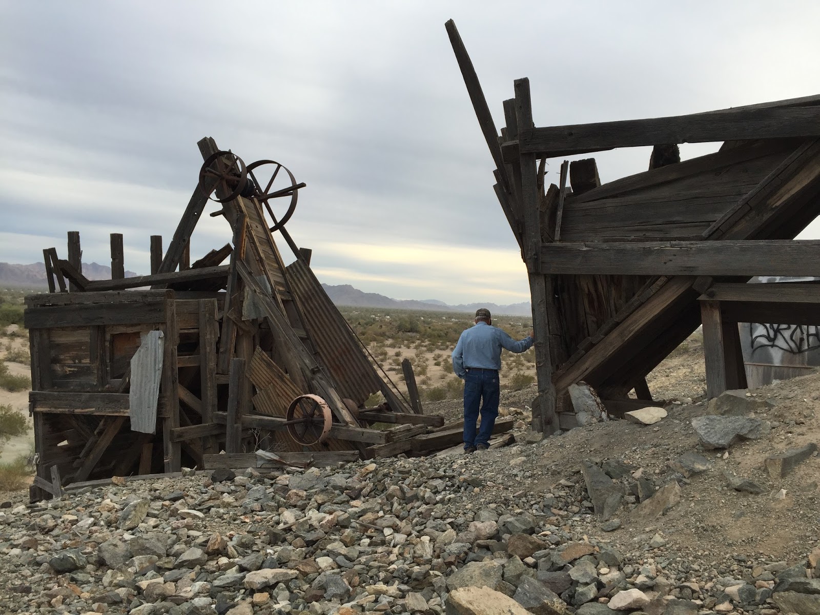
An steel skeleton remains at the mine site. 
It was a mill of some sort to process the ore before it was transported down the mountain. 

We continued on past the Senator Mine, the road turns into a 4 wheel drive road.
The views spectacular. 

A young couple at our campground in Prescott build this 5th wheel. They're very talented. 
The interior even more awesome. They've had such an interest in their "home" that they're considering building units to sell. 

Visiting Don Robinson's Gold King Mine Collection.
While in Prescott, we drove up Mingus Mountain to the old mining town of Jerome.  
Our destination was to revisit the long closed Gold King Mine located a short drive from downtown Jerome. We first visited this place when Ryan and Erin were with us several years ago. 
Story goes….about 30 years ago an interesting fella (Don Robinson) bought the closed mine and started his ever growing collection of old mining equipment, unique old trucks, tractors and whatever else. He opened the old mine grounds to the public to share his collection.
Being a master mechanic he kept many things in his collection in running order. He had a couple saw mills, one powered by a 1943 submarine engine he bought from a military sale. (The sawmills are still sawing wood.) He had a beautiful vintage race car, which he started up for us with the crank start. At one time he raced this car in vintage car races. He certainly looks like an old miner; hat, beard and all…he even had a  mule on the property, named Pedro. There are rows of faded rusted trucks, (he liked Studebakers), fuel tankers, dump trucks, old buses and firetrucks. I quickly changed my first impression of thinking this was a junk yard to thinking this is a vehicle heaven, where vehicles can die peacefully on a mountain top and not succumb to the crusher. 

There’s something about seeing an old rusted truck resting peacefully among the wildflowers and trees. On this return visit we were so looking forward to visiting with Mr Robinson again, but we sadly learned he had turned very ill and passed away only weeks ago. 
He charged very little to get into his wonder land, his enjoyment came from talking to people and showing them around. I don’t know how anybody can carry on as he did… we wonder what will become of his collection and gold mine. 

His vintage race car. 
Truck named "The Other Woman"

A sign along the driveway into this place says "Rust in Peace".


Wednesday, November 2, 2016

Flagstaff & Prescott AZ, 10/2016

We were fortunate to be in northern Arizona to catch some fall colors.
The view from Flagstaff's Snow Bowl Ski area. 


Loved walking in the stands of Aspen trees.

Williams AZ, an old Rt 66 town.
Old gas stations, motels and diners line old Rt 66, which is the main street through Williams. The town has done a great job preserving the old buildings which gives it a western cowboy town feel. Outdoor dining, musicians playing on outdoor patios and the train depot where the Grand Canyon Excursion train departs daily makes this a great town to visit and walk around. 

A Ponderosa Pine at our campsite in Prescott. If you look closely you'll see hundreds of small round holes in the bark. Here we learned about the Acorn Woodpecker. They peck round holes in the thick part of the bark, only penetrating deep enough to stuff an acorn in. It does not kill the tree. The woodpeckers fill the holes with acorns for the upcoming winter months. We enjoyed watching them at work, they're very busy this time of year. Funniest was when a squirrel climbed the tree and took an acorn, he had several woodpeckers squawking and chasing him, it was quite a commotion.

My favorite RV so far! I could live in this one forever.
A young, very talented, couple built this 5th wheel, it's amazing. Note all the little windows across the top, they fashioned it to take on the look of an old railroad car. The interior even more impressive, rustic and so well done. They were the talk ("rock stars") of the campground. 

Sunday, October 16, 2016

Sunrise at the Grand Canyon, Oct. 2016

Sunrise at the Grand Canyon...another check-off on the bucket list.
We got up at 5:00am for the drive to the Grand Canyon to watch the sunrise. We were amazed to see a line of cars at the entrance gate when we arrived. Simply put, the sunrise was beautiful. Even with all the people, it was so quiet and peaceful...we were in church...we were in awe of this place.  Couldn't help but look up and praise God. The sunrise show slips by quickly,  the colors in every direction change by the minutes.   

Mather Point, a popular overlook at the visitors center.
People were perched on every view point that was accessible. 

After sunrise we started our hike into the Canyon on the South Kaibab Trail, our destination being Skeleton Point. Above is a pit toilet at Cedar Point about 1.5 miles down from the rim. The cowboys did some cleaning and maintenance checks, the toilets are composting using solar power and other creative practices. (Much better than my initial thought of having to haul the "stuff" out.) One mule was loaded with several white buckets, not sure what they were used for?  There weren't many open spots on the trail, most of the trail is narrow with rock walls on the inner side and a drop off on the canyon side. It's a beautiful trail, very scenic in all directions. We chose this trail over the more popular Bright Angel trail because it is less traveled and used by the mule trains. We had lunch at Skeleton Point, the views amazing with our first view of the Colorado River at the bottom. 

Yellow caution sign posted on the building reads: 
"CAUTION, DOWN IS OPTIONAL 
UP IS MANDATORY"

Mule trains haul supplies to Phantom Ranch at the bottom of the Grand Canyon. There is also a service that hauls overnight hikers gear into the canyon. There is a $70.00 fee per backpack each way, the weight limit being 30lbs. We were thrilled to meet the mule trains.  

Mule train takes a short rest at Cedar Point.

If there's a negative about this trail, it's the trail. 
Going down was enjoyable and quite easy. Going up not so much. Not only is it a steep climb for 

3 miles, but many stretches are very rutted with uneven steps, the ruts are from all the mule traffic. Instead of looking about at the views, one had to look down and watch where your feet were landing. Funny thing...I didn't notice all the steep switchbacks going down. 
A 7 mile hike... another challenging trek completed, so worth it!

Wednesday, May 18, 2016

Lee's Ferry on the Colorado River, 5/2016


Staging area... Rafters preparing for their raft trip down the canyon.
Lee’s Ferry - located about 8 miles south of Page AZ (& the Glen Canyon Dam) on the Colorado River. Here the river begins it’s twisting journey into the Grand Canyon. Rafters “Running the Colorado River” begin their trip here. To protect the Grand Canyon and it’s beauty, permits are required to raft down the river, only a limited number are issued. There are 2 types of rafting trips, private and commercial. Private rafters can wait as long as 10 years for a permit. Trips last from 3 to 18 days. The 3 day trips involve a people exchange at the bottom of the Grand Canyon. A tour company flies people in and out of the canyon by helicopter to make the exchange. 
Lee’s Ferry got it’s beginning in the early 1870’s, the leaders of the Mormon church in Utah wanted to colonize Arizona, but the Colorado River blocked the way. Lee’s Ferry was the only place for hundreds of miles that a trail could be built to access the river (the Colorado for the most part has steep cliffs on both sides). In 1871 John Lee began his ferry operation and started a small settlement nearby. John Lee was actually running from the law due to his involvement in a massacre spearheaded by Mormons in Utah. He was arrested, tried and executed 6 years later. The ferry operation was passed onto another Mormon, the ferry service operated for 40+ more years. Ferry service ended as a bridge was completed over the Colorado.  

Raft loaded with food and camping gear. 
Tour companies supply the food (even prepare the meals) and all the camping gear needed for the trip, the gear is carried on seperate rafts. 
I talked to a rafter preparing for departure down the river the next morning. He was part of a private group with several rafters. They expected to be on the river 18 days, 225 miles to their take-out point. What an adventure. 


Bridge over the Colorado near Lee's Ferry.

Hiking Cathedral Wash at Lee's Ferry. Great hike with part being in a slot canyon, some boulder scrambling required. The canyon hike was about 2 miles down to the Colorado River. Our timing was perfect, we reached the river just as several rafters were passing by.


Lonely Dell Ranch - a Mormon settlement and home to families who operated Lee’s Ferry. 
The last private owners planted an orchard back in the 60’s. Today it is still maintained by the National Park Service, visitors are allowed to pick ripe fruit for their eating enjoyment. (Within limits and not to be re-sold). We picked apricots, the trees were loaded with the fruit, the orchard was beautiful and well maintained. 

Tuesday, April 19, 2016

Zion National Park, April 2016

I haven't been keeping up with our blog all that well...we've had such a great visit in Zion that I decided to do a Zion blog. At some point I will back track and catch up...we have seen some amazing places since the last blog from Quartzite until now. 

Watchman Campground in Zion Park. We lucked out, due to a cancellation, we  landed this site. The Virgin River is right below the split rail fence with mountains behind it. 
Can't beat this for a dinner table with a view!

Along the trail on one of our hikes in Zion. I look pretty small amidst the huge rocks. 

Another beautiful view on one of our hikes. The Virgin River flows through the canyon, this is the same river that's behind our campsite. 


Angels Landing, probably the most challenging hike we've ever done. This area was called Scouts Lookout, many people turn around at this point. The brave (or crazy) continue on another mile up the ridge to the very top. The views are breathtaking to say the least. Although most the time I couldn't look down, sheer cliffs of 1,000 ft drops on both sides of the ridge. Yup, we were pretty proud of ourselves. Checked it off our bucket list. Great hike but we probably wouldn't do it again, once is enough.
Back in the day...before the trail was developed...it was said nobody could make it to the top except the angels...thus the name, Angels Landing. 
Chains in certain areas help with scrambling up the rocks and hanging onto the mountain.

Near the top...sheer cliff over the edge.
The Virgin River can be seen below.

The hikers (red shirts) below are making their way upward through a series of 21 switchbacks called Walter's Wiggles. Named after a man who helped develop this trail many years ago. I was thinking of my dad when on Walter's Wiggles. 


Zion is beauty beyond words, so colorful, one of the most beautiful places we've had the privilege of visiting. This entire adventure is such a privilege and blessing.  

Wednesday, March 2, 2016

More from Quartzsite AZ, (Jan 2016)

Day trip to Yuma from Quartzsite.
While visiting our friends in Yuma, they gave us the grand tour of this city. Much agriculture here, the fields were brilliant green with several different kinds of lettuce growing. Other produce growing included spinach, broccoli, cauliflower and onions. We stopped at a farmers market and bought some fresh fruit and vegetables. 
 They drove us a little further south to the border town of San Luis. We were surprised to see this border wall, it's 20 feet high, a steel curtain of sorts. They say it's effective here, although a wall of this type only exists in certain areas on the border.  

Another day trip was a drive north to Parker AZ, we followed the Colorado River which separates California and Arizona. We found these wild burros in a little wayside on the river. They didn't seem too wild, although this was as close as we got. I think they're looking for a hand out or picnic left overs. They were fun to watch. 

The Colorado River.
We were surprised at how clean the water is and such a beautiful blue color.

We drove to Parker to see what the "Parker 425, Blast in the Desert" was all about.
It's an off-road race that covers 425 miles in the desert, it was exciting and amazing to see.  

Remnants of another abandoned mine near Quartzsite.

Native American grinding holes near Quartzsite.
We joined in a group tour with the Escapees Geocachers. (More on Geocaching later. ) My friend and I are demonstrating how the Native American women ground corn into flour. This is the site of an ancient settlement, the surrounding cliffs have interesting petroglyphs.


We've been learning about geocaching and are thoroughly enjoying this new activity. Geocaches have taken us to places we wouldn't have discovered on our own, often times interesting history is associated with the placement of the geocache. Here is one of our first geocache finds, (see tin box under stump), somebody put a fake snake there which got quite a reaction out of me. ha ha.

We found another geocache a few miles out of Quartzite, this desert area is known as Company B. It was a training ground for the military during WWII, General Patton was stationed here for a time. Rocks served as boundaries for roads or tent placements. We also found a big letter "B" drawn out with rocks. 

Another day trip was to the abandoned mining town of Swansea.  The town once had a population near 300 residents. The mines first closed in 1912. New owners restarted the mining operations and continued on for several years. The post office closed in 1924 as population decreased, by 1937 the mines were shut down for good and Swansea became a ghost town. 

Huge metal cover over one of the deep mine shafts at Swansea.
The shaft goes straight down, we couldn't see the bottom. Swansea is listed as a Historic Town Site, interesting signage tells of the history and the layout of the town. Some of the old housing units are being restored, others have crumbled to the ground and all that remains is an outline of adobe rubble. 

Beautiful colors in rocks at Swansea.
I don't know what the minerals are in these rocks but the colors were outstanding. Wondering if the turquoise color is from copper since Swansea processed copper ore from area mines.