Thursday, November 5, 2015

Redwoods in northern CA

Marker at a trail head.
 In walking among these gigantic trees that are 1,000+ years old and feeling such
calm quiet peace...for a moment it feels like all is right in the world. 


I've included some quotes about the Redwoods because in many cases 
my words just don't seem adequate.

This is their temple, vaulted high,
And here we pause with reverent eye,
With silent tongue and awe-struck soul;
For here we sense life's proper goal.
To be like these, straight, true and fine,
To make our world like theirs, a shrine;
Sink down, O traveler, on your knees,
God stands before you in these trees.
Joseph B Strauss "The Redwoods" 1932  


The Eternal Tree House was once a huge Redwood estimated to be 2500 years old when it was cut by loggers in the early 1900’s. The remaining stump contained a huge cavern caused by fire. It was used by Indians, trappers and even livestock for shelter. In 1950 the 20 ft area was made into a gift shop. Although the original trunk of the tree is gone, the stump remained and continued living. Today it is the parent of more than a dozen Redwoods which grow from the stump’s roots and are now more than 40 ft high. The Eternal Tree House is located on the Avenue of the Giants highway in the little burb of Redcrest. Our campground was also on the Avenue of Giants highway about a mile from here. Ancient Redwoods RV park was one of our favorite RV parks.


The Redwoods have remarkable resilience. They are nearly immune to insects, decay and fire. They have a thick bark (up to 12” thick) that provides protection, it contains a resin that is distasteful to termites and insects. When exposed to fire the bark chars and turns into a heat shield of sorts. What an amazing tree.
Hard to believe but this Redwood is still alive and thriving, the branches on top looked like any other healthy Redwood. These cavities have been caused by fires over many years. Intense fires can penetrate the bark through cracks, the heartwood in the middle of the tree is "empty wood or dead wood", the tree gets it's nourishment from the outer wood under the bark.    

Can you ever take too many pictures of the Redwoods?? 

In looking at my photos on the computer the answer is  yes

As much as I tried, photos don't capture the grander of these trees and the forest. 

There are many different groves within the Redwood National Park, these groves were either from land donated to the park or money was given to the Redwood Preservation Foundation and the grove was then named after them. The groves range from small acreages to 1,000's of acres. To mention a few, there is the Roosevelt Grove, Lady Bird Johnson Grove, Rockefeller Grove and Founders Grove. 
We heard about the Stout Grove and didn't realize until we arrived at the trailhead and read the sign that we were quite familiar with this name. Back where we come from in WI, the Stout name was huge in logging. There are streets named after him and his partner, Knapp. The Stouts built a beautiful mansion of a house on an island on Red Cedar Lake, accessible only by boat. It has passed hands several times but is still known as Stout Island. We learned that the Stouts were also involved in the lumbering business in the Redwoods.   


As the trees grow in height they often lose their lower branches creating 
this beautiful canopy over head.   


In the early 1900's, Charles Kellogg built a camper out of a hollowed out Redwood tree and traveled the country bringing awareness to preserving the ancient Redwood trees. It was called the Travel Log. It was mounted on WWI military truck. Today we realize what a gift his (and other's) forward thinking has given us. 


Many Redwoods with burned out cavities are alive and thriving in the forest.


I liked our reflection in this sign. 

Redwoods sprout new trees from the fallen trees or limbs. 
Here you can see a new tree sprouting from a rotting redwood.  


The redwood is one of the few conifers that sprout from the stump and roots, and it declares itself willing to begin immediately to repair the damage of the lumberman and also that of the 
forest-burner.” ~John Muir 

A tree hug.

Another Redwood that survived the ravages of man (the tree is still alive).
 Known as the girded tree, back in the 1900's it was stripped of it's lower bark which was used for siding on a small building that served as a tourist attraction. 


Hard to believe this is all natural.

This grove with all the greenery looked like a well kept park, but it was just another grove in the forest. I'm not sure why this one had so much of the clover like greenery growing while others didn't...but it sure was beautiful. 

Our campground on the Avenue of the Giants highway.


Thursday, October 22, 2015

Fern Canyon, 

in Praire Creek Redwoods State Park  Klamath CA

Oct. 2015, Fern Canyon is how I imagine a rainforest to be. After a 10 mile drive on a narrow dirt road, thru Redwoods and a little creek, we arrived at the trail head. The drive itself was beautiful, Fern Canyon the frosting on the cake.  
A mile trail thru the canyon with a creek at the bottom. 80 ft high walls covered with at least 5 different kinds of ferns. Huge overhanging trees on top the ridge. Water dripping down from the hanging gardens and the sound of trickling water, all make for a glorious hike.


Was wishing I had my mudders on. After several creek crossings, most over logs or wobbly branches strewn across the trickling water, I ended up with wet feet as did many  other hikers we met. 


Tom shows off his skills and keeps his feet dry.

 It was like walking in a terrarium.
Interesting note, a part of Jurassic Park 2 was filmed here. 


A Banana Slug, easy to see how they get their name. They can grow up to 9”.
All for now. Stay tuned for more of the Redwoods to follow. 


Wednesday, October 14, 2015


Lassen Volcanic National Park, CA.

 Aug/2015 - This park was a hidden gem for us, we saw it on the map in route to Oregon and decided to check it out, so glad we did. We ended up camping here for several days, there was much to see and so many hiking trails. Our campground was on this little Lake Manzanita, there was a nice trail around the lake. We watched a few sunsets from this point. The highest mountain in the background is Lassen Peak which last erupted in 1917. We hiked to the top, which was a challenging climb for me but well worth it with beautiful views, we were surprised to find small patches of snow on the top, although it was very windy and cold up there.

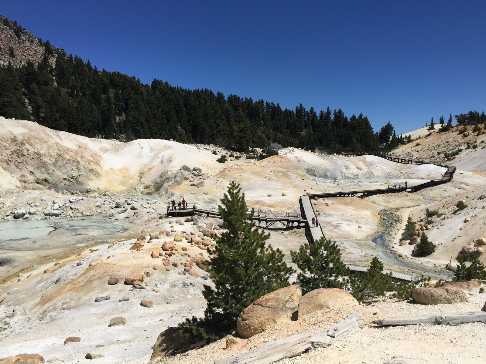
Lassen reminded us of a little "Yellowstone". We walked the boardwalks over this hydrothermal area. Warnings to stay on the walkway explain the surface may look solid but in places it's a thin crust with boiling acidic water underneath. I liked the colors in the landscape. 
There have been many eruptions in the park and surrounding area. We climbed another volcano, Cinder Cone, a type of eruption where the top and inside blew out. It was a steep climb, all on loose cinder, another good workout worth the effort. I've never seen anything like it. Note the little pine tree growing on the top of this volcano, others on the left also making a come back. There's a trail that circles the top (which we did) but we were exhausted and didn't take the trail down into the center. 

View from the top of Cinder Cone over the back side. We were blown away when we looked over the back side and saw this view of the lava and cinder beds. It was like being in a watercolor painting. 


Heading down Cinder Cone, much easier than going up. 


At the bottom looking back at Cinder Cone, I feel a sense of accomplishment. 
(You can see part of the trail.) 


Friday, October 2, 2015

Oregon, Port Orford - September 2015

Oregon travels, south to north:
Our son asked if the beaches are crowded...I added this photo for him and his wife, they're accustomed to busy New England beaches. Those are our tracks, we walk a beach somewhere everyday and never tire of it because they're all different. 
Regarding our blog...I’ve fallen behind, will blame some on lack of internet. The Oregon State Parks on the coast have sparse internet/cell service. Other than that little inconvenience, the State Parks are very nice with beautiful ocean beach locations. Our trip thru Oregon started in the south central part of the state, we meandered north thru Bend and up the middle to the The Dallas on the Columbia River, the river divides the states of Oregon and Washington, the area known as the Columbia Gorge. The Lewis and Clark expedition followed the Columbia river to the coast (the historic Lewis and Clark Trail). Once we reached the NW corner of Oregon, we followed the coast north to south. As I write, we’re in Port Orford, near the southern border. This is where I’ll continue our blog and in time will back track on some of the highlights from earlier travels. 

Port Orford is the kind of little town we’re drawn to, not all touristy. The fishing industry appears to be the main source of employment. Interesting note, some of the fish from this little port are shipped out alive to restaurants. They’re placed in large water filled containers for shipping. I think the most fascinating thing about Port Orford is the dock itself, it’s called a dolly dock and is one of only 2 in the U.S. Since the town’s open-water harbor isn’t protected from the crashing sea swells, boats in the commercial fishing fleet are hoisted in and out of the harbor by a huge crane everyday, the boats are loaded on a trailer and kept safe up on the cement dock. It’s quite a sight to watch. 


Days End - Fishing boat being lifted up onto the dock.


 The hoist swings the boat over the dock.

This is a different boat but you can see it being loaded onto a trailer.

On our beach walk - Sea Anemones
Sea Anemones are considered to be the flower of the sea, they look like plants but are really meat eating animals. They attach to rocks in shallow water or tide pools, they wait for their food to swim by then sting it with their tentacles. (I like flowers of most any kind, it was a nice surprise to find these in a small pool on the beach.)


A little drive south of Port Orford on Hwy 101. 
Every beach, every view, every day, all different and all so amazingly beautiful.


Another spectacular view, looking towards Port Orford. 

Sunday, September 13, 2015

 August 2015, Virginia City, Nevada

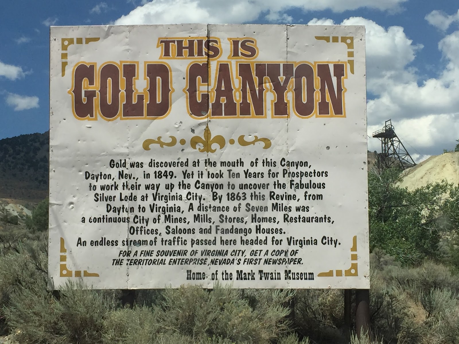
 With our interests in history and historic buildings, we throughly enjoyed visiting the old mining town of Virginia City. I remember our family (back in the day) watching Bonanza, an old western show that was centered around Virginia City. There remains an old saloon by the name of Bonanza in town, (I was hoping Hoss, Little Joe and the others would come riding into town, but it didn't happen.) Aside from the TV series, there is so much history here from the mining days. The Gold Canyon area had many operating gold and silver mines and several little towns, the largest and most prosperous being Virginia City. This is a very picturesque town with old west saloons, many of the buildings and interiors being original, boardwalks and 19th century victorian era houses, all very awesome.


I loved all the old colorful lights hanging from the ceiling inside this western saloon.

Not the greatest picture, but I thought this 15-foot tall portrait of Lady Luck was amazing. Her dress is made of 3,261 silver dollars minted in Nevada. Her belt is made from 28 twenty-dollar gold pieces, her choker and bracelets minted from dimes. She is located in the original Silver Dollar Saloon as a tribute to the mining era. (If you're wondering about her security, the portrait is located next to the busy bar and covered with glass.)

Main Street Virginia City - "The Comstock Lode, as the wide spread gold and silver bonanza was called, turned Virginia City into the first truly industrial city in the West in the years following the 1857 discovery; the population soared from 4,000 in 1862 to 25,000 in 1874.  $500 million (billions in today’s economy) attracted all kinds, mostly males, Europeans, and Chinese."  
An interesting side note, Samuel Clemens worked for the newspaper in town and this is where he first took on the pen name of Mark Twain. The museum in the left was the newspaper office where he worked. 

In the hills around Va City we saw several bands of wild horses. Some in the distance and others eating grass by the side of the road. There are road signs posted to watch for wild horses just like the deer warning signs we had back home. 

We continue to work our way north, heading for the Columbia River in Oregon. 

Monday, August 24, 2015


Colorado over the 4th of July, 2015

We love Colorado and the mountains. On this day we went wheeling on the Ophir Pass, found a little snow at the pass, elevation 11,789 ft. The views in every direction are just spectacular.  
Wild flowers blooming in the mountain meadows


After camping in Ouray for a couple nights we moved to Ridgeway State Park about 20 miles from Ouray. Ridgeway is also a beautiful area, this photo was taken at sunset from a trail behind the Visitor Center in the Park.
Back in Winslow AZ, we've seen some amazing sunsets here, (no photo editing). 

Grand Canyon North Rim

We liked the north rim of the Grand Canyon much better than the south. I think mostly because it is way less crowded and touristy. You can walk around and find places to sit and look at the canyon and be alone (for the most part). We drove out to several points (above) and were the only people there.
Waiting for a sunset that never really materialized because of the clouds, none the less the Grand Canyon is ever changing with the clouds and light of the day, it's a magical place. 

Raining in the canyon.
The clouds and little rain showers that popped up added to the show. 


Monday, August 10, 2015

June 2015 - Leaving Taos NM, heading for Arizona.


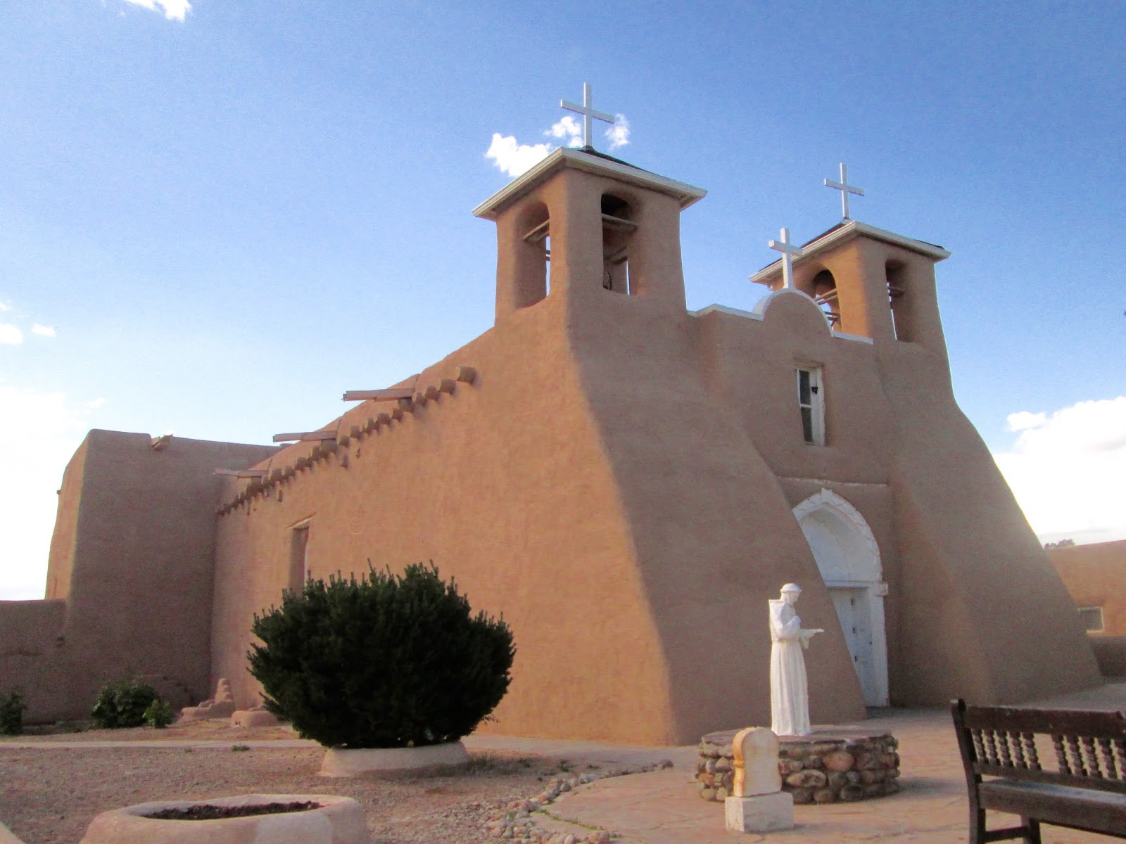
This is probably my favorite of all the missions we visited, I like the simple lines and adobe construction. 
San Francisco de Asis Mission Church is in a historic district of Taos. After several years of construction, the mission was completed in 1815. The Taos Chamber of Commerce claims it is one of the most photographed and painted churches in the world. Photographer Ansel Adams and painter Georgia O'Keeffe to name a few of the artists. 

The mission was the center of a fortified plaza. Plazas were enclosed with thick walls which offered protection against Indian (Comanche in this case) attackers. The plazas also served as gathering places for the community. 

 Flagstaff AZ, The Great Race. 

We learned the Great Race was coming to Flagstaff and decided to check it out, so glad we did, it's such an amazing event which we knew nothing about, until now.
The Great Race is a world famous old car rally that's been in existence for 33 years. It's a 9 day race that covers over 2,000 miles in vehicles 1972 or older. This year the race started in MO and ended in CA, traveling over sections of old Route 66 which brought the rally thru Falgstaff. The cars each have a driver and a navigator. They're given precise instructions everyday that detail every move down to the second. It's not a race of speed but of time. They are scored throughout the day at checkpoints.  Following the precise instructions is key and the primary job of the navigator.
People lined the streets and cheered as the cars pulled into Flagstaff. 

All ages of cars.

All kinds of vehicles.

These proud guys were from Finland. There were also a couple teams from Japan.

I liked the tow truck, who would ever think of entering a tow truck in a road rally.


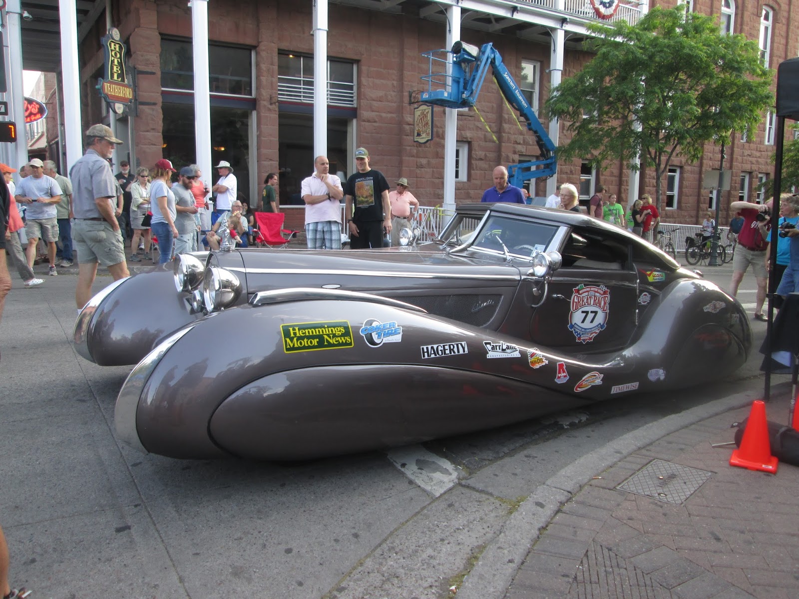
A rather unusual custom built car.


From looking on their web site, this car was the overall winner. The cars lined the streets for a few hours making for an amazing car show. We talked to a husband/wife team (so interesting) and saw they placed in the top 20...cool. 
If you're interested in entering, save your coins, the entry fee is $5,500.00. The winner is awarded a cool $50,000 in prize money. 
Next year the race will be following the Lincoln Highway, starting in CA and ending in IL. We'd love to see the race again, it's very possible with our moving home.